Our planet Earth is the place where we live; its characteristics influence our life. Earth is very large in comparison with the life forms that inhabit it. We can identify two main parts: a solid one, which is the Earth´s crust, and a liquid one, made up of the seas, rivers, lakes, and other, waters.
Long ago, many people wondered if the Earth was round, if there was an end, or if they could fall off if they went out too far.
Maps
In the beginning, maps were very hard to make. Many explorers lost their lives trying to diagram newly discovered lands. Cartographers have come a long way in discovering and mapping out the Earth.
It is very
interesting to look back at previous versions of maps to see how things have
changed from the way they were perceived many years ago.
Maps help
us to see large areas of the world in small pictures. By looking at maps, you can find where you are, find where you want to go, or discover where distant and fascinating
places on Earth are.
Atlas
A collection of maps bound into book form for research and investigation is called an atlas. Today many atlases are found in multimedia formats to present photographic geographic features.
Latitude and Longitude
The Earth
is a giant globe, so how can we describe where a certain point is on it? The way to locate appoint on the surface of
the Earth is by a system of imaginary lines called latitude and longitude.
What is Latitude?
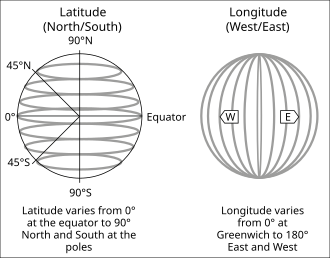
- Latitude is a horizontal imaginary east-west line of location, north or south of the equator. The equator is an equal distance from the north and south poles. The equator is the latitude line with the value of 0 degrees. It is the starting point for measuring latitude.
- Latitude values tell the distance between the equator and pints north or south poles. The equator is the latitude line with the value of 0 degrees. It is the starting point for measuring latitude.
- Latitude values tell the distance between the equator and points north or south of it on the surface of the Earth. All lines of latitude are parallel to the equator, so they are referred to as parallels. The Tropic of Cancer is the parallel north of the equator and the Tropic of Capricorn is south of the equator. Both are an equal distance between the equator and the poles.
What is Longitude?
Longitude lines, also known as meridians, are imaginary vertical lines running from north to south, used to describe the location of a place on Earth, east or west of the zero or prime meridian is the origin where time zones are based, located at Greenwich, England.
The prime
meridian divides the Earth into western and eastern hemispheres.
Meridians
are lines that run parallel to the prime meridian.
Did you know?
Thanks to latitude and longitude, we can explore the whole world from anywhere! Whether you're in the mountains, by the sea, or dreaming of faraway places, these magical lines help us stay connected and discover our amazing planet. Let the adventure begin!
Don´t miss the next blog to continue learning and practicing English!
Love,
Teacher Ana


Comments
Post a Comment